In the 1800s, pioneers headed west to explore new frontiers, but in the 21st century, SDSU scientists are traveling to the Far East in search of opportunities.
Dennis Helder, head of the image processing lab and associate dean of research for the Jerome J. Lohr College of Engineering, has been racking up the frequent flyer miles to network with scientists in the Asian remote sensing market. Since 1990, the SDSU lab has been calibrating images from the Landsat satellite series through its work with the NASA Goddard Space Flight Center in Greenbelt, Md., and U.S. Geological Survey Center for Earth Resources Observation and Science, commonly known as EROS, in Baltic.
During a two-month period last fall, Helder made one trip to Indonesia for the Asian Conference on Remote Sensing with a stopover in Thailand and then two trips to China as part of Peking University’s foreign experts program.
Calibrating satellite images
Signals from satellite sensors produce digital images composed of pixels, Helder explained. “Each pixel measures the amount of energy welling up from Earth.â€
When those images are calibrated, they become data sets that scientists can use to document and analyze changes occurring on the Earth’s surface over time—in the case of Landsat, over a 40-year period.
“If we don’t calibrate the images, then they are only pretty pictures,†Helder commented.
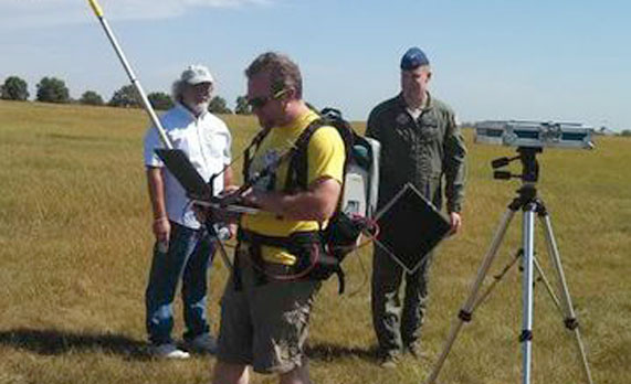
To ensure that these images are accurate, scientists use vicarious calibration sites. The researchers go to the site and take measurements, which they then compare with satellite images of the same site, Helder explained. One such site exists in a field south of 3M in Brookings.
“The team measures reflectance and atmospheric properties to predict how much energy is at the top of the atmosphere for the satellite to observe,†Helder said.
However, these data-gathering excursions are time-consuming and expensive.
Increasing accuracy, broadening horizons
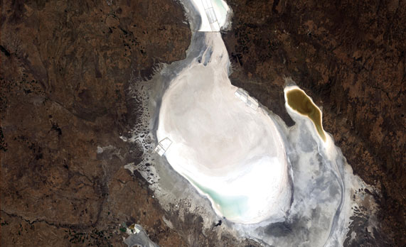
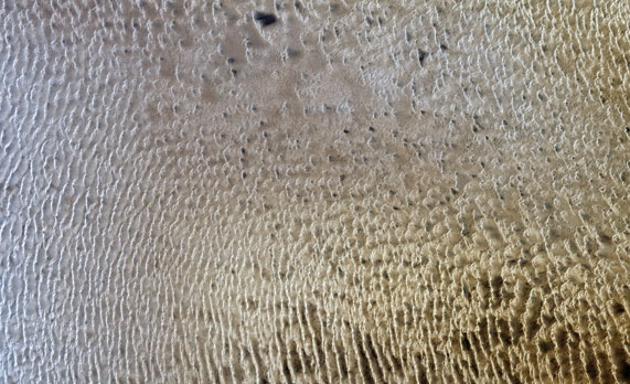
Over the last decade, Helder and his team have been developing less costly and more accurate ways to calibrate satellites. The team is using pseudo-invariant calibration sites, which are called PICS, remote areas with limited rainfall and human influence, such as deserts and dry lake beds.
Based on 25 years of observation from Landsat 5 using a desert site in Libya, Helder and his team determined that the surface properties of these PICS do not change over time. Therefore, any changes in the satellite imagery of these sites must be due to the instrument, rather than the subject.
“When a satellite observes these test sites, it should measure the same amount of energy each time,†Helder said. “This approach is less expensive because you don’t have to put a team in the field at the site or do a lot of data processing from the field team’s measurements.â€
Developments such as these put the lab in a position to offer its calibration expertise to governmental and commercial agencies working with optical remote sensing satellites, particularly those in Asia.
“It is critical to broaden our horizons in order to insure the world has the most accurate instruments possible to study global change,†Helder stated.
Working with Thai space agency
In August 2010, Helder and imaging engineer Larry Leigh represented the United States as part of an international field campaign evaluating Tuz Gölü, one of the largest salt lakes in the world, as a calibration site.
Teams from 10 nations participated in the three-week mission in central Turkey.
There they met Morakot Kaewmanee, a research scientist with Thailand’s Geo-Informatics and Space Technology Development Agency, where she was in charge of satellite calibration, data acquisition and product quality.
A relationship grew through the interactions following that work, and in 2012, Kaewmanee came to the SDSU lab as a visiting scientist.
Kaewmanee compared the calibration of the Thai satellite, Thaichote, with that of the U.S. Landsat 5 satellite. Her research showed that the Thaichote satellite calibration was stable but needed a slight modification to improve its accuracy. She presented these results at the 2012 Asian Conference for Remote Sensing in Thailand.
“We gave them a taste of what we can do,†Helder said.
That led to negotiating a two-year agreement— SDSU will develop an atmospheric model for the satellite and then train scientists at the Thai space agency, commonly known as GISTDA, to perform calibration to ensure the accuracy of satellite images.
Helder credits Kaewmanee and her work as the conduit for this agreement. “She knew GISTDA and how we could work together,†he said. “She did all the negotiating for us.â€
After attending the 2013 Asian Conference on Remote Sensing in Bali, Indonesia, on Oct. 21-24, Helder, Leigh and Kaewmanee spent a day in Bangkok, Thailand, finalizing the contract with GISTDA.
Based on his conversations at the conference, Helder anticipates that the lab can build similar relationships with other Pacific Rim countries that are developing their remote sensing capabilities, such as Indonesia, Vietnam and South Korea.
Exploring possibilities in China
When Helder gave a presentation on calibration at the Joint Agency Commercial Image Evaluation workshop in 2012, he found a networking opportunity with China. Thanks to that connection, Peking University sent doctoral student Ming Zhi Wang to do research at the SDSU imaging lab.
A week before Wang went back to China, he submitted Helder as a candidate for China’s foreign experts program. Helder told him that a two-month program wouldn’t work for him, but two weeks might.
Helder forgot about it until he received a call from Wang in July. “You were accepted,†he told Helder. “Now you can come to China for two months.â€
Eventually, Helder discovered that he could fulfill the program requirements with two one-week trips, the first in October and the second in December.
During his October trip, Helder learned what the satellite imaging research group in Beijing does and was able to make connections with faculty and students. In addition, he visited the Chinese Meteorological Administration in Beijing, the nation’s largest calibration group. And it turns out that one of the scientists he met at Tuz Gölü in Turkey works there.
The Chinese have been characterizing a large region in the Gobi desert called Dunhuang as a possible calibration site for about 10 years. “This might be a good opportunity to connect to that group,†he says. Current plans are to develop an international calibration campaign at Dunhuang in 2015.
Plus, Peking University officials are interested in having graduate students from SDSU spend a month on campus taking a class or two in English. “This would be a good learning experience for them,†Helder said, and would open the doors to further collaboration with Chinese scientists.
Christie Delfanian


